FLARES
A software that deals with subsonic industrial flaresFLARES is a Windows application for sizing industrial flares, for the evaluation of their thermal and acoustic impact and for the calculation of the flue gas composition. Calculations are made according to the ANSI/API (American Petroleum Industry) Standard 521, sixth edition January 2014, ISO 23251, AP42 and US-EPA methodologies.
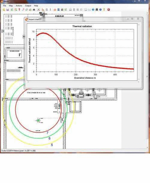
You can load a digital cartography and graphical results are automatically georeferenced over it. It is thus possible to quickly evaluate the thermal and acoustic impact at specific locations. All graphical representations can be printed or copied, and integrated in technical reports. Textual results can be exported into ASCII files. Thermal radiation levels and noise levels can be exported in KML files for Google Earth.
![]() Download and evaluate FLARES for free.
Download and evaluate FLARES for free.
![]() Buy an annual subscription through FastSpring secure site with credit card, PayPal, money order or bank transfer.
Purchase price refers to a 1-year subscription license (single platform). Software updates are available for users with a valid subscription.
Buy an annual subscription through FastSpring secure site with credit card, PayPal, money order or bank transfer.
Purchase price refers to a 1-year subscription license (single platform). Software updates are available for users with a valid subscription.
Here are some features of FLARES:
- Sizing (i.e., calculation of height and diameter) of subsonic industrial flares according to a specified allowable radiation
- Optionally include solar radiation contribution
- Calculation of thermal radiation of subsonic and sonic flares
- Calculation of noise levels of subsonic and sonic flares
- Calculation of flue gas composition
- Calculation of the effective stack parameters for atmospheric dispersion modelling according to the US-EPA SCREEN3 and TCEQ (Texas Commission on Environmental Quality) methodologies
- Works with SI (International Standard) and USC (United States Customary) units
- Flame tilting calculated with the Simple approach and with the Brzustowski and Sommer approach
- Allows to load and georeferentiate a base map
- Georeferentiation done automatically if the base map file has an associated world file
- Allows to position the flare stack over the base map
- Thermal radiation levels and noise levels are shown at any point moving the mouse over the base map
- Plots radiation levels and noise levels over the base map
- Base map and levels can be copied, saved and printed
- Stack can be exported in KML format for Google Earth
- Thermal radiation levels and noise levels can be exported in KML format for Google Earth